Anatidae Site Network in the East Asian Flyway
Network Sites
as at June 2004
[ Map in PDF ]
[ in Japanese ] [ Back ]
[ What's New ] |
[ Site Network ] |
[ Action Plan ] |
[ Links ] |
[ Atlas ] |
[ Sitemap ] |
[ Japanese pages ] |
[ Network Sites ] |
[ Activities ] |
[ Introduction ] |
[ Contacts ] |
|
|
Anatidae Site Network in the East Asian Flyway Network Sitesas at June 2004 [ Map in PDF ] [ in Japanese ] [ Back ] |
[ Jump to: Map of distribution of Sites ]
In May 1999 the Site Network was launched with linking Anatidae sites of international importance. As at April 2002, 27 key sites from 6 countries have joined and taken activities in the Site Network, that is 8.0% of 337 key sites identified in the 1999 Anatidae Atlas (Miyabayashi & Mundkur 1999), covering c. 5.3 million ha.
SITE |
LISTED |
COORDINATES |
AREA (ha) |
|
Russia |
[Ramsar] |
|||
14 May 1999 |
44°53'N, 132°30'E |
310,000 |
[R] |
|
14 May 1999 |
50°05'N, 115°32'E |
172,500 |
||
14 May 1999 |
52°17'N, 106°22'E |
12,100 |
||
14 May 1999 |
73°10'N, 126°00'E |
2,850,000 |
||
14 May 1999 |
73°50'N, 100°00'E |
1,600,000 |
[M] |
|
(formerly Chazy Zapovednik) |
14 May 1999 |
52°30'N, 091°00'E |
274,600 |
|
Mongolia |
[Ramsar] |
|||
14 May 1999 |
48°10'N, 099°43'E |
6,110 |
[R] |
|
14 May 1999 |
47°46'N, 102°46'E |
2,510 |
[R] |
|
China, P.R. |
[Ramsar] |
|||
14 May 1999 |
47°55'N, 134°22'E |
198,100 |
[R] |
|
13 Jan 2001 |
22°30'N, 114°01'E |
1,500 |
[R] [S] |
|
Korea, R. |
[Ramsar] |
|||
14 May 1999 |
36°40'N, 126°24'E |
13,704 |
||
Japan |
[Ramsar] |
|||
14 May 1999 |
45°10'N, 142°20'E |
1,607 |
[R] |
|
14 May 1999 |
43°05'N, 145°06'E |
|||
14 May 1999 |
43°03'N, 144°54'E |
4,896 |
[R] [C] |
|
14 May 1999 |
42°59'N, 144°24'E |
7,726 |
[R] [C] |
|
14 May 1999 |
43°20'N, 141°43'E |
41 |
[R] |
|
14 May 1999 |
40°10'N, 140°04'E |
60 |
||
14 May 1999 |
38°37'N, 141°06'E |
150 |
||
14 May 1999 |
38°02'N, 140°44'E |
|||
14 May 1999 |
37°50'N, 139°13'E |
390 |
||
14 May 1999 |
37°54'N, 139°15'E |
163 |
||
14 May 1999 |
37°49'N, 138°53'E |
76 |
[R] |
|
14 May 1999 |
36°19'N, 136°17'E |
10 |
[R] |
|
14 May 1999 |
35°15'N, 136°05'E |
65,602 |
[R] |
|
14 May 1999 |
35°26'N, 133°17'E |
30 |
||
18 Apr 2002 |
42°42'N, 141°43'E |
510 |
[R] |
|
Philippines |
[Ramsar] |
|||
14 May 1999 |
13°09'N, 121°22'E |
14,567 |
[R] |
|
[Ramsar] for a country of contracting party to the Ramsar Convention on Wetlands, with link to the Annotated Ramsar List of Wetlands of International Importance for the country in the Ramsar website;
[R] for a site that has been listed to the Ramsar, with link to Ramsar database sheet for the site at A Directory of Wetlands of International Importance (2002 -- 7th edition), Wetlands International;
[S] and [C] for a site that also joined to the Site Network of Shorebirds and Cranes, respectively;
[M] for a site that also listed in the UNESCO MAB Biosphere Reserve, with link to the Directory of it in the UNESCO Man and Biosphere website;
[H] for a site that also inscribed on or is covered by the inscribed site on the World Heritage List, with link to the Directory of it in the UNESCO World Heritage website; and,
The name of each site itself links to another page in this website of brief information on the site especially on the Anatidae populations in the site, some of which have links to further information available on the world-wide web.
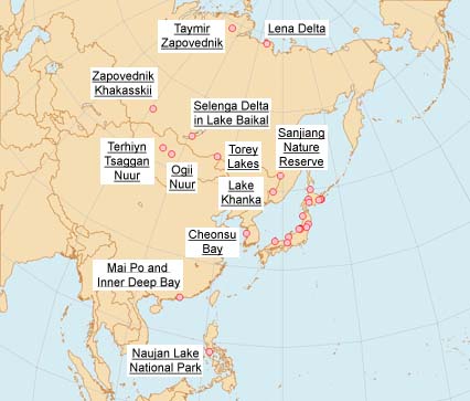
Distribution of Network Site in the flyway, cliccable for opening introduction page to each site at the name of each site on the map. The other map of Japan sites is below this map.

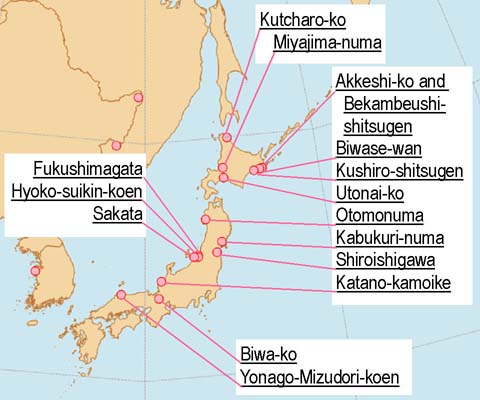
Distribution of Network Site in Japan, cliccable for opening introduction page to each site at the name of each site on the map. The other map for sites outside Japan is above this map.

[ Top ] [ in Japanese ] [ Map in PDF ] [ Back ]
[ Network Sites ] |
[ Activities ] |
[ Introduction ] |
[ Contacts ] |
[ What's New ] |
[ Site Network ] |
[ Action Plan ] |
[ Links ] |
[ Atlas ] |
[ Sitemap ] |
[ Japanese pages ] |